Prepare your season
Trail running route generator: Kliva vs Strava, Garmin Connect and Trailrouter
By Simon Busch · · 17 min read ·
Short answer
Kliva ranked 1st on all 4 routes tested on 18 November 2026 in Switzerland and France, on a routing engine built for trail running. On the loops it stays within 6.8% of the distance you ask for and within 1.8% of the D+. Strava goes as far as +123.3% on D+, Trailrouter -48.2%. Below are the raw numbers for each tool, including where a competitor does better on one measure.
A good trail route generator keeps to the distance and the D+ you ask for, goes over trails and avoids doubling back. We put the same request to four tools, from the same start points, and we publish what each one drew.
Kliva is our product and we ran this test ourselves, so the raw numbers sit next to every score and we show where a competitor does better. Kliva's routing engine is our own, built for trail running. It is available in Belgium, Switzerland and France for now.
The ranking at a glance
Verbier14 km · 550 m D+
Kliva
1st76
Trailrouter
2nd73
Strava
3rd50
Garmin Connect
4th40
Lausanne Sauvabelin10 km · 250 m D+
Kliva
1st86
Trailrouter
2nd57
Garmin Connect
3rd56
Strava
4th44
Chamonix12 km · 600 m D+
Kliva
1st85
Garmin Connect
2nd63
Strava
3rd54
Trailrouter
4th45
Verbier to Le ChâbleOne-way, no target
Kliva
1st81
Strava
2nd63
Garmin Connect
3rd62
Score out of 100: trail 30%, distance 20%, D+ 20%, repeated passages 15%, paved 15%. See the method
Case by case
Verbier, 14 km loop with 550 m of D+
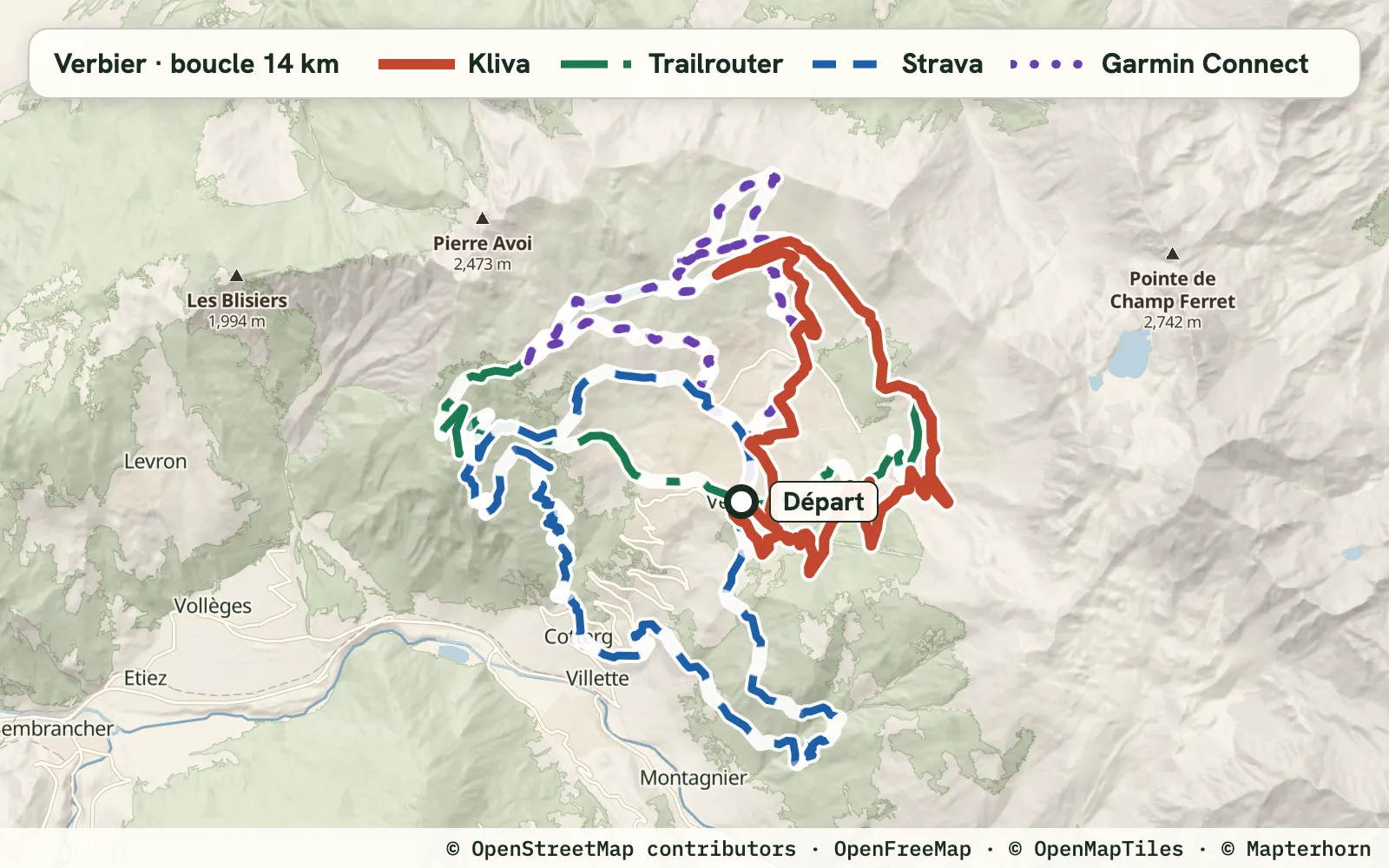
Requested: 14 km · 550 m D+
Each bar is one route, on the same km scale for the four tools: the vertical line marks the requested distance, solid is trail covered once, hatched is ground already covered, dotted grey is paved or road and the dashed outline is what the map does not classify.
Kliva1stscore 76 · 13.45 km · 540 m D+
D+ -1.8% on target4 of 4Trailrouter2ndscore 73 · 13.63 km · 605 m D+
D+ +10.0% on target4 of 4Strava3rdscore 50 · 15.45 km · 1,228 m D+
D+ +123.3% off target2 of 4Off target: distance (+10.3%), D+ (+123.3%)
Garmin Connect4thscore 40 · 12.40 km · 750 m D+
D+ +36.4% off target1 of 4Off target: distance (-11.5%), D+ (+36.4%), distinct trail (6.73 km for 14.00 km requested)
“x of 4” counts the checks passed: start within 100 m of your point, distance and D+ within 10% of the request, distinct trail worth at least 60% of the requested distance.
Why Kliva comes first here: it passes all 4 checks, like Trailrouter, with 10.71 km of distinct trail. Strava has more (12.00 km) but passes only 2 of 4 checks.
This is the closest route. Kliva ranks 1st with 76 against 73 for Trailrouter. Trailrouter is closer to the requested distance (-2.6% against -3.9%), Kliva is closer on D+ (-1.8% against +10.0%) with more trail (81% against 79%). Strava offers 1,228 m of D+ for 550 m requested (+123.3%). Garmin Connect has no D+ setting in the creator we used: 750 m (+36.4%), and 64 for its best proposal.
All the measurements : Verbier
| Tool | Score out of 100 | Length | Distance gap | D+ | D+ gap | Trail | Distinct trail | Repeated | Longest paved | Start |
|---|---|---|---|---|---|---|---|---|---|---|
| Kliva | 76 ★ | 13.45 km | -3.9% | 540 m | -1.8% ★ | 81% ★ | 10.71 km | 0.7% | 896 m ★ | 44 m |
| Trailrouter | 73 | 13.63 km | -2.6% ★ | 605 m | +10.0% | 79% | 10.73 km | 0.0% ★ | 1,880 m | 2 m ★ |
| Strava | 50 | 15.45 km | +10.3% | 1,228 m | +123.3% | 79% | 12.00 km ★ | 0.0% ★ | 1,693 m | 63 m |
| Garmin Connect | 40 (64) | 12.40 km | -11.5% | 750 m | +36.4% | 55% | 6.73 km | 9.9% | 2,115 m | 62 m |
Lausanne Sauvabelin, 10 km loop with 250 m of D+
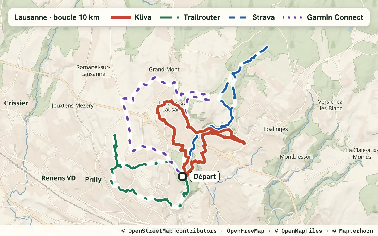
Requested: 10 km · 250 m D+
Kliva1stscore 86 · 10.07 km · 252 m D+
D+ +0.8% on target4 of 4Trailrouter2ndscore 57 · 8.99 km · 269 m D+
D+ +7.6% on target2 of 4Off target: distance (-10.1%), distinct trail (3.88 km for 10.00 km requested)
Garmin Connect3rdscore 56 · 10.64 km · 289 m D+
D+ +15.6% off target2 of 4Off target: D+ (+15.6%), distinct trail (4.30 km for 10.00 km requested)
Strava4thscore 44 · 10.65 km · 343 m D+
D+ +37.2% off target1 of 4start 432 m from your pointOff target: start (432 m), D+ (+37.2%), distinct trail (4.91 km for 10.00 km requested)
“x of 4” counts the checks passed: start within 100 m of your point, distance and D+ within 10% of the request, distinct trail worth at least 60% of the requested distance.
Why Kliva comes first here: it is the only one to pass all 4 checks, with 7.87 km of distinct trail (the most of this case).
Kliva stays on the request: 10.07 km (+0.7%) and 252 m of D+ (+0.8%). Strava shows as much trail (82% for both), but 38.0% of its route is covered twice (2.3% for Kliva): 4.91 km of distinct trail remain, against 7.87 km for Kliva. Its start is 432 m from your point, and it offers 343 m of D+ for 250 m requested (+37.2%). Trailrouter stays 10.1% under the distance, with 44% trail. Garmin Connect: 41% trail.
All the measurements : Lausanne Sauvabelin
| Tool | Score out of 100 | Length | Distance gap | D+ | D+ gap | Trail | Distinct trail | Repeated | Longest paved | Start |
|---|---|---|---|---|---|---|---|---|---|---|
| Kliva | 86 ★ | 10.07 km | +0.7% ★ | 252 m | +0.8% ★ | 82% ★ | 7.87 km ★ | 2.3% | 413 m ★ | 51 m |
| Trailrouter | 57 | 8.99 km | -10.1% | 269 m | +7.6% | 44% | 3.88 km | 0.0% ★ | 1,475 m | 1 m ★ |
| Garmin Connect | 56 (59) | 10.64 km | +6.4% | 289 m | +15.6% | 41% | 4.30 km | 0.3% | 4,205 m | 34 m |
| Strava | 44 (51) | 10.65 km | +6.5% | 343 m | +37.2% | 82% ★ | 4.91 km | 38.0% | 1,317 m | 432 m |
Chamonix, 12 km loop with 600 m of D+
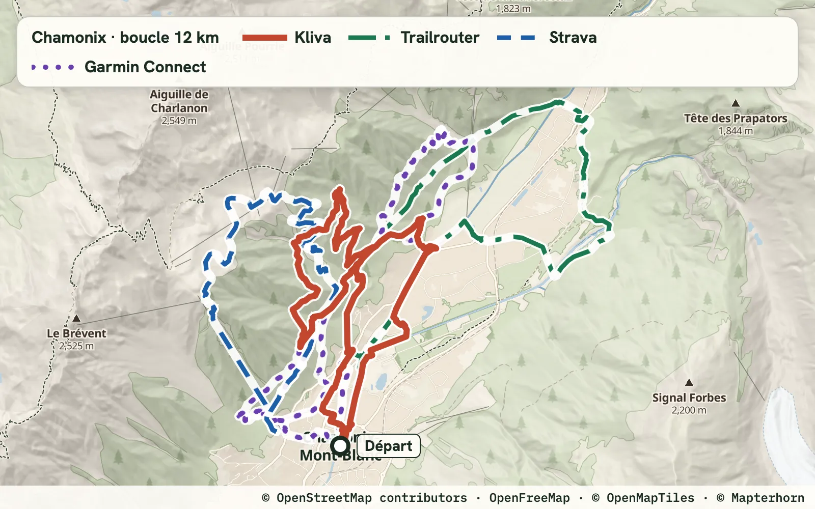
Requested: 12 km · 600 m D+
Kliva1stscore 85 · 11.18 km · 603 m D+
D+ +0.5% on target4 of 4Garmin Connect2ndscore 63 · 12.22 km · 853 m D+
D+ +42.2% off target3 of 4Off target: D+ (+42.2%)
Strava3rdscore 54 · 7.66 km · 943 m D+
D+ +57.2% off target0 of 4start 621 m from your pointOff target: start (621 m), distance (-36.2%), D+ (+57.2%), distinct trail (7.01 km for 12.00 km requested)
Trailrouter4thscore 45 · 11.02 km · 311 m D+
D+ -48.2% off target3 of 4Off target: D+ (-48.2%)
“x of 4” counts the checks passed: start within 100 m of your point, distance and D+ within 10% of the request, distinct trail worth at least 60% of the requested distance.
Why Kliva comes first here: it is the only one to pass all 4 checks, with 9.66 km of distinct trail. Garmin Connect has more (9.96 km) but passes only 3 of 4 checks.
Kliva draws 11.18 km (-6.8%) and 603 m of D+ (+0.5%). Garmin Connect is closer to the requested distance (+1.8%). Strava's first proposal has the most trail (94%) but is 7.66 km, which is -36.2% on distance, with a start 621 m from your point. Trailrouter stops at 311 m of D+ (-48.2%). Garmin Connect climbs 853 m (+42.2%) with 87% trail.
All the measurements : Chamonix
| Tool | Score out of 100 | Length | Distance gap | D+ | D+ gap | Trail | Distinct trail | Repeated | Longest paved | Start |
|---|---|---|---|---|---|---|---|---|---|---|
| Kliva | 85 ★ | 11.18 km | -6.8% | 603 m | +0.5% ★ | 90% | 9.66 km | 2.4% ★ | 315 m | 8 m |
| Garmin Connect | 63 (64) | 12.22 km | +1.8% ★ | 853 m | +42.2% | 87% | 9.96 km ★ | 4.3% | 746 m | 37 m |
| Strava | 54 (58) | 7.66 km | -36.2% | 943 m | +57.2% | 94% ★ | 7.01 km | 2.8% | 154 m ★ | 621 m |
| Trailrouter | 45 | 11.02 km | -8.2% | 311 m | -48.2% | 73% | 7.54 km | 8.5% | 1,168 m | 4 m ★ |
Verbier to Le Châble, one-way
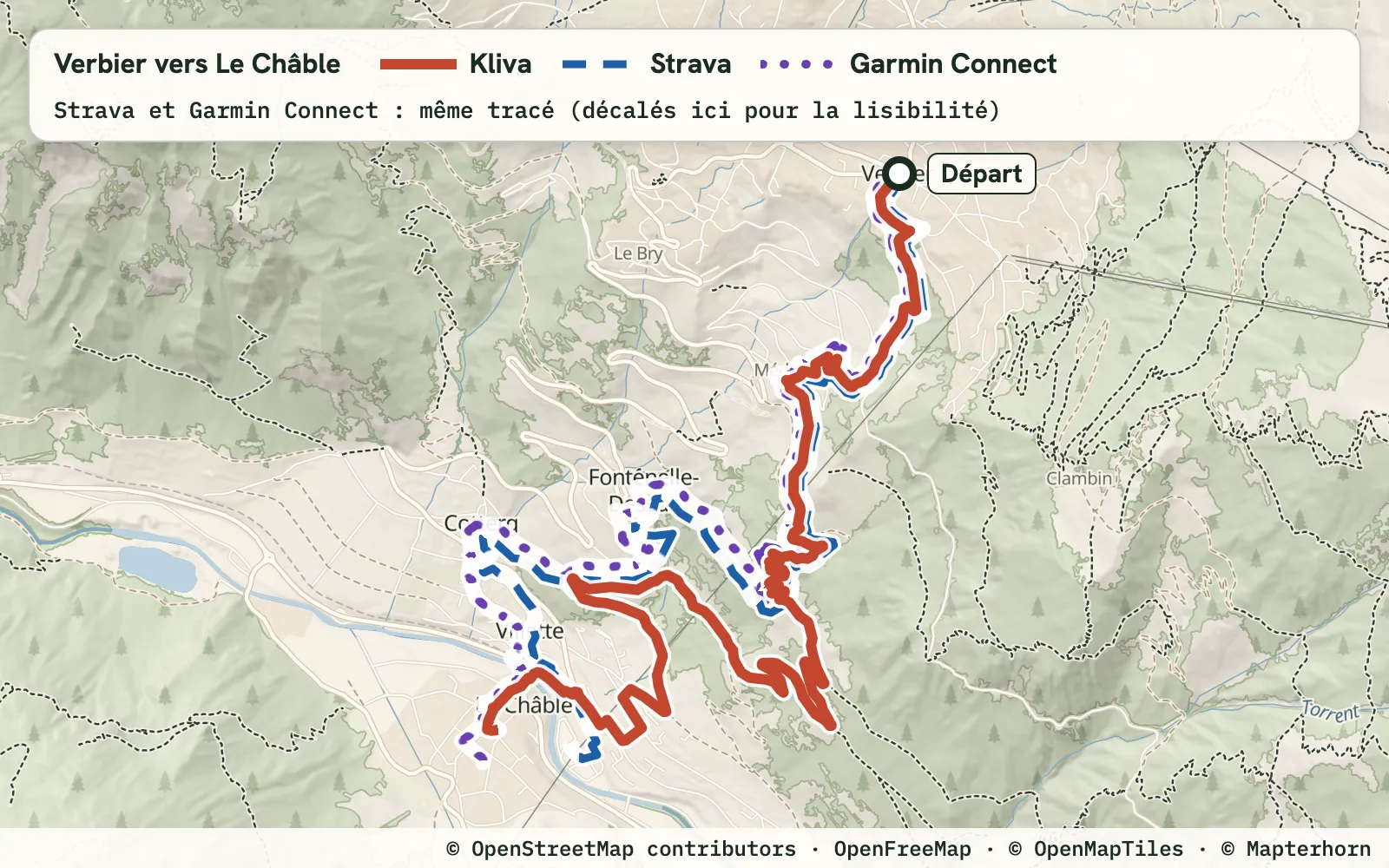
Requested: one-way, no distance target
Kliva1stscore 81 · 6.49 km · 23 m D+
3 of 3Strava2ndscore 63 · 5.43 km · 3 m D+
1 of 3arrival 291 m from your pointOff target: arrival (291 m), distinct trail (3.04 km of 5.43 km)
Garmin Connect3rdscore 62 · 5.43 km · 29 m D+
1 of 3arrival 137 m from your pointOff target: arrival (137 m), distinct trail (2.91 km of 5.43 km)
“x of 3” counts the checks passed: start and arrival within 100 m of your points, distinct trail worth at least 60% of the route's length. With no target there is no distance or D+ check.
Why Kliva comes first here: it is the only one to pass all 3 checks, with 5.13 km of distinct trail (the most of this case), at the cost of a longer route (6.49 km against 5.43 km for Strava and Garmin Connect).
With no distance target, the distance shown is the one offered. Strava and Garmin Connect each offer 5.43 km, with 57% and 55% trail. Kliva offers 6.49 km, with 81% trail: the route is longer, so read it together with the score of 81 against 63 and 62. Strava and Garmin Connect end 291 m and 137 m from your arrival point, Kliva 39 m. Trailrouter only offers loops, so it was not measured here.
All the measurements : Verbier to Le Châble
| Tool | Score out of 100 | Length | D+ | Trail | Distinct trail | Longest paved | Start | Arrival |
|---|---|---|---|---|---|---|---|---|
| Kliva | 81 ★ | 6.49 km | 23 m | 81% ★ | 5.13 km ★ | 369 m ★ | 44 m | 39 m ★ |
| Strava | 63 | 5.43 km | 3 m | 57% | 3.04 km | 636 m | 33 m ★ | 291 m |
| Garmin Connect | 62 | 5.43 km | 29 m | 55% | 2.91 km | 633 m | 81 m | 137 m |
Method
Protocol
- Test of 18 November 2026 (Kliva run again on 19 November 2026): 4 routes, 3 loops and 1 one-way, in Verbier, Lausanne (Sauvabelin) and Chamonix.
- Same start point and same request for every tool.
- First proposal of each tool kept, best proposal obtained in brackets.
- Kliva: loop, exact D+ target, avoid roads on. The other tools have no field for an exact D+ target in the settings we used, so we left it as it was (Garmin Connect: no D+ setting in the web creator). Trailrouter: loop mode, green areas at maximum. Garmin Connect: web creator, Trail type, automatic mode.
- Kliva's engine changed twice during the test window, and the other tools were not run again. Kliva's numbers are from 19 November 2026 (run again after the trail share change), the others from 18 November 2026. First change, the village-exit fix: before it, Kliva was 2nd in Verbier (67 against 73 for Trailrouter). Second change, the trail share: Kliva's scores before then after, Verbier 76 then 76, Lausanne Sauvabelin 74 then 86, Chamonix 78 then 85, Verbier to Le Châble 82 then 81.
- Komoot is not included: the GPX export needs a paid region unlock.
Measures
- D+ recomputed for every tool with the Copernicus GLO-30 elevation model and the same smoothing.
- Each route is split into four parts, measured on the resampled trace: trail covered once, the repeated stretch (ground that retraces an earlier passage of the same route), paved or road, and the rest, « unclassed » (stretches the OpenStreetMap map does not tie to any way, and a small gap between the length of the file and the resampled trace).
- “x of 4” counts four checks on a loop: start within 100 m of your point, distance within 10% of the request, D+ within 10% of the request, distinct trail worth at least 60% of the requested distance. Limits are inclusive: Trailrouter's D+ gap in Verbier, 10.0%, is on target, its distance gap in Lausanne, 10.1%, is not. Gaps are shown with one decimal for that reason.
- With no target (the one-way only) there are three checks: start within 100 m of your point, arrival within 100 m of the arrival point, distinct trail worth at least 60% of the route's length. There is no D+ tag.
- Trail and paved share come from OpenStreetMap labels. This is the same open data Kliva's engine uses, which favours an OpenStreetMap-based engine, so we publish the raw measures and not only the score.
- Score out of 100, a summary: trail 30, distance 20, D+ 20, repeated 15, longest paved stretch 15. Each criterion is worth 1 at the ideal and 0 at its limit (25.0% off on distance, 50.0% off on D+, 20.0% repeated, 1,000 m of paving in a row). With no target, distance and D+ are left out of the score.
Can Strava draw a trail loop?
In our test, yes: Strava drew a loop for every request. Its D+ was off by +123.3% in Verbier, +37.2% in Lausanne and +57.2% in Chamonix, where its first proposal was 7.66 km for 12 km requested.
Why is Komoot not in the comparison?
Komoot is not included: the GPX export needs a paid region unlock. Without a GPX file we cannot measure the route the same way as the others.
Which route generator hits the D+ you ask for?
Over the 3 loops, the largest D+ gap is 1.8% for Kliva, 42.2% for Garmin Connect, 48.2% for Trailrouter and 123.3% for Strava. D+ is recomputed for all of them with Copernicus GLO-30.
Which countries does Kliva cover?
Belgium, Switzerland and France for now. We add countries as the data is ready.
How do I send the route to my watch?
Save the route, then export a GPX file. On a Garmin, you can also send it straight to the watch with its turn prompts.
Where does Kliva do worse?
In Verbier, Trailrouter is closer to the requested distance (-2.6% against -3.9%), and Kliva scored only 67 before the village-exit fix. In Lausanne, Strava has as much trail (82% for both), Kliva starts 51 m from your point against 1 m for Trailrouter, and it covers 2.3% of its route twice against 0.0%. In Chamonix, Strava has more trail (94% against 90%), and Garmin Connect is closer to the requested distance (+1.8% against -6.8%). From Verbier to Le Châble, the Kliva route is longer than the others.
Download the Kliva route
A trail can be missing from the map, closed for the season or cross private land: always follow the signs on the ground.